
Latest topics
» Kriegsspiel: A Bridge Too Far (AAR)by Martin Yesterday at 6:31 pm
» targeting artillery targets
by Saucier Tue Oct 29, 2024 12:15 am
» Grog can't make it
by Grog Fri Sep 13, 2024 5:59 pm
» Toggle vegetation = true not working
by popeadrian Fri Aug 30, 2024 11:43 pm
» 1862 Kriegsspiel manual by Von Tschiscwitz
by modron Thu Aug 29, 2024 8:23 pm
» SOW Scenario Generator
by popeadrian Sun Aug 25, 2024 5:39 pm
» Guide to map making?
by popeadrian Wed Aug 14, 2024 1:44 am
» SOWWL Artillery batteries
by Uncle Billy Thu Jul 11, 2024 3:15 pm
» Set Up for SOWWL NAPOLEON GAMES For Kriegspiel style
by Uncle Billy Tue Jul 09, 2024 10:35 pm
» The New SOWWL Is Now Available On Steam
by Grog Mon Jul 08, 2024 8:14 pm
» Boxed KS set Wallington NT near Morpeth
by Martin Sat Jun 08, 2024 3:50 pm
» Help Request-Artillery Behavior
by Dutch101 Mon May 27, 2024 4:08 pm
Statistics
We have 1600 registered usersThe newest registered user is Moromir
Our users have posted a total of 30539 messages in 2305 subjects
Log in
Trying to Make Scaled Down Waterloo Map
3 posters
Page 1 of 1

Trying to Make Scaled Down Waterloo Map
![]() Mr. Doran Sat Nov 11, 2017 5:57 am
Mr. Doran Sat Nov 11, 2017 5:57 am
Hello, some of you may remember a post I made over a year ago stating my intention to make a large scale Waterloo scenario for KS. The tools to make that happen were not available at the time but now I think this is more of a possibility. My situation is best summed up by my post on the norbsoft forum.
----------------------------------------------------------------------------------------------------------------------------------
Greetings,
I have been trying to learn and familiarize my self with the map editor the past few days. My goal is to create maps of historical battles at smaller scales than the vanilla game maps are based off of; the first map I am trying to bring to fruition is Waterloo at around 1/3rd scale to the current one we have. I am currently too incompetent to figure out how to create a map file from scratch without the editor crashing instantly so I started playing around with the vanilla Waterloo map files. I eventually scale down the topography to what I am looking for and scale down the the RGB jpegs to fit the new map size.
I compile the file in the editor and see it spits out a single lsl file; looking at the file structure in the scourge of war folder at other maps and with what little I can find online it is clear to me there is more to a functioning map than the single lsl file. I am not sure what to do at this point besides replacing the Waterloo lsl in the base game to try to test the map in game. Results are the topography works fine along with the ground texture painted in the places where they should be but the trees, roads, and other decals are on the same place they are on the vanilla map. The Landscape Studio help documentation says the vegetation map is controlled by vegmap.tga but have been unable to locate any file named as such. From what I can see from the file structure and various postings on the internet there are other elements such as csv files for roads and such that I have also been unable to locate or know what to do with them even if I did.
Situation for me at this point is basically a standstill at my current knowledge level. Any level of help would be greatly appreciated. I have included the files I have been working with as a dropbox link if they can be of any help.
www.dropbox.com/s/jazr7orboisyxmh/Waterloo%20Files.rar?dl=0
My steam profile if anyone wants to contact me in a more direct fashion: steamcommunity.com/profiles/76561198014028214/
Edit: screen shots of what the topographical scale looks like.
Only three brigades are necessary at this scale to make a visually appealing and practical representation of d'Erlon attack on the Anglo Allied left flank
gyazo.com/6e7ac1abeade1ce166921cafcd33b1aa
gyazo.com/ecbeca3d9d141ae806491ccb7b113345
gyazo.com/476d76ca2c275dfa4725bbb7bf69e334
gyazo.com/7ca208785ee4b7402fe830744a6258ec
------------------------------------------------------------------------------------------------------------------------------------
Any references, documentation, or form of help on the map making procedure would be greatly appreciated.
-Doran

Mr. Doran- Posts : 18
Join date : 2015-08-23
Re: Trying to Make Scaled Down Waterloo Map
![]() Didz Sat Nov 11, 2017 12:18 pm
Didz Sat Nov 11, 2017 12:18 pm
Talking about the Waterloo map, I was interested to see a video by the Waterloo Project which was explaining their mission to produce a digitised version of Siborne's map of the battlefield.
Siborne was the only historian to conduct a thorough survey of the battlefield and create an accurate map of the terrain before it was vandalised by the Belgian government to produce the Lion mound. It, therefore shows all the terrain heights correctly and even includes an accurate record of the field boundaries and which crops were growing in each field at the time of the battle.
An accurate digital version of this map would be a god send for wargamers and wargame developers, but so far my enquiries about its availability to the public have gone unanswered.

Didz- Posts : 155
Join date : 2017-07-03
Age : 69
Location : UK
Re: Trying to Make Scaled Down Waterloo Map
![]() Martin Sat Nov 11, 2017 12:41 pm
Martin Sat Nov 11, 2017 12:41 pm
Do we know the source for the SOW Waterloo map?
Martin (J)
Martin (J)
Martin- Posts : 2523
Join date : 2008-12-20
Location : London
Re: Trying to Make Scaled Down Waterloo Map
![]() Mr. Doran Sat Nov 11, 2017 4:55 pm
Mr. Doran Sat Nov 11, 2017 4:55 pm
It depends on what you mean by the source. If you are referring to topological data they used I have no idea. If you are referring to the physical files I am trying to modify the Waterloo map the vanilla game comes with; I am specifically using the Waterloo.lpj located in SDKv2 included in the NSD Tools folder.
Mr. Doran- Posts : 18
Join date : 2015-08-23
Re: Trying to Make Scaled Down Waterloo Map
![]() Didz Sat Nov 11, 2017 5:39 pm
Didz Sat Nov 11, 2017 5:39 pm
I don't know the source, but its certainly not accurate.
I've noticed a number of features that are missing completely including the spur between La Haie Sainte and Hougoumont that was the major tactical feature on the Allied right, and the defile on the road south of La Haie Sainte that caused so much trouble for the French Cuirassiers trying to support D'Erlon's attack.
In fact the rise just south of La Haie Sainte, which is still visible today is completely missing from the SOW map resulting in French artillery having a clear LOS on the farm, which wasn't the case in reality.
Also of course all the field boundaries are missing as are most of the hedgerows, and the shambles that Vivian and Vandler claim existed just west of Papelotte which prevented their cavalry brigades riding to the assistance of the Union Brigade when it was attacked by Jacquinot's Lancers.
Actually having just logged into the game to check I realise that 'The Mound', which was the main defensive feature behind the sandpit used by the 95th Rifles is missing (or barely marked by a few bushes) although on the day it deflected D'Erlon's attack columns to their right and was only taken later by a determined assault.
Also the road from the crossroads to the west above La Haie Sainte is completely flat, whereas in reality it was (and i think still is) a sunken lane which caused the Household Cavalry and the French Cuirassiers considerable problems in the opening stages of the battle, and later became a nest of French skirmishers that caused havoc amongst the British squares on the slope above it.
So, yes there are a few discrepancies.
The map in SOW just seems to be an abstract lifted from a rather poor history book. It has all the main features made famous by the English myth, but none of the detail.
Didz- Posts : 155
Join date : 2017-07-03
Age : 69
Location : UK
Re: Trying to Make Scaled Down Waterloo Map
![]() Martin Sat Nov 11, 2017 9:43 pm
Martin Sat Nov 11, 2017 9:43 pm
Thanks Didz. That was the question I was asking.
Martin (J)
Martin (J)
Martin- Posts : 2523
Join date : 2008-12-20
Location : London
Re: Trying to Make Scaled Down Waterloo Map
![]() Mr. Doran Sat Nov 11, 2017 11:10 pm
Mr. Doran Sat Nov 11, 2017 11:10 pm
It is relatively easy to make topographical adjustments; if I can get good enough descriptions of what the real features looked like then it can be made reality. But as I said in the OP I am currently stuck on progress of turning the topography and painted terrain into a map with functioning roads and vegetation.
Mr. Doran- Posts : 18
Join date : 2015-08-23
Re: Trying to Make Scaled Down Waterloo Map
![]() Didz Sun Nov 12, 2017 8:12 pm
Didz Sun Nov 12, 2017 8:12 pm
Well the only accurate map of the battlefield as it was in 1815 is the one produced by Siborne. But it would certainly make things easier for you if you could obtain a copy of the digital model mentioned in the video.
As far as vegetation is concerned the field boundaries and crops growing in them were noted by Siborne, as was the existence and height of the hedgerows between them. I noted on another thread that for some reason SOWG seems to have much better textures for vegetation than SOWW, and i was thinking of trying to copy the graphics files over to see it I could improve the look of the Waterloo maps. The rye and wheat in SOWW is particularly unimpressive compared to SOWG.
++++
Last night I spent some time trying to find an online image of the print I recall seeing of the view from La Haie Sainte towards the French positions on the southern ridge. I distinctly remember this print because its the only one I've seen that shows both the sharp rise of ground immediately to the south of the farm that protected it from the French artillery, and the defile caused by the cutting created to lessen the slope of the road to Charleroi. However, I could find a copy online and I suspect the image i remember is hiding in one of my many books on the battle and short of thumbing through all of them I'm not going to find it.
These cuttings are a feature of many roads of the period, both in Europe and America and were both a natural result of the poor road surface and the passage of wheeled carts, and also of deliberate action by local farmers to reduce the degree of slope, or flatten the road surface so that heavily laden farm carts could navigate them easier and with less risk of overturning.
I've also come across at least three primary references to this rise and the defile in the Charleroi road. Baring himself mentions the rise as a nuisance and risk, he claimed that the orchard occupied by his riflemen was overlooked by this rise which the southern edge of the orchard partially mounted, such that French skirmishers were able to approach well within effective musket range of his men in the orchard and fire down into them making the orchard extremely dangerous, especially for people like himself who were mounted and thus clearly visible. He also mentions that when the French assault began it appeared almost without warning less than 50 yards from his men in the orchard forcing a rapid withdrawal through the barn into the farm.
Another account is from a French Artillery officer, whose name I can't recall off-hand. He left a journal which is very interesting as it provides one of the few detailed records of how French artillery were deployed and controlled both before and during a battle. He states that on the morning of the battle he rode forward onto the rise south of La Haie Sainte, with the intention of marking the positions of the Grand Battery which it was intended would occupy the rise in order to bombard the farm and the Allied Centre. His job was to place markers along the rise indicating the position to be taken up by each gun, and then as the guns came up to their marks to indicate the line of fire to be assumed by each gun and make sure that wheel marks were placed to regulate the direction of fire once the battle started. However, as he was going about this task he quickly became aware that there were riflemen in the orchard very close to him, and he had to abandon his task and find less suitable locations for his guns further back on the main ridge. As it happens the French artillery were not able to deploy on the rise until much later in the day, after the KGL rifles had been driven out of the orchard and the farm had been invested by the 13e Legere. In fact, it may have been the guns brought forward to occupy this rise which were overrun during the charge of the Union Brigade, who may actually have caught them in the process of deploying on it, as there are numerous accounts of the limber drivers being with the guns when they were overrun which would not normally be the case.
The final account which was somewhat of a puzzle for me for some time was the description of 30-50 Cuirassiers being trapped in a defile trying to fallback from an attack and massacred by British infantry fire. I spent some time trying to work out where this event occurred, and at first I was looking behind Hougoumont but could never find a defile that was so restrictive it would have trapped a whole troop of French cavalry. It wasn't until a few years ago that i realised I was probably looking in the wrong place and that the defile was most likely along the Charleroi road. It makes perfect sense of course that the French heavy cavalry that were providing support for D'Erlon's attack would have deployed behind the rise south of La Haie Sainte. It was the closest they could get to the infantry assault without attracting direct artillery fire from the Allied Ridge, because the slope would have deflected any shot fired at them just as the Allied Ridge protected Wellingtons cavalry. So, French cavalry returning from a sortie would naturally have been heading back down the Charleroi Road towards the dead ground where they were being mustered and reformed for the next attack.
The interesting thing here is the inconsistency of the images and maps one see's of the farm and the road. Contemporary prints of the period conflict. Some show the Charleroi Road heavily sunken into the terrain, particularly as it climbs the slope towards the Allied ridge and as it climbs the slope of the rise the the south of the farm. It also shows that the road and the farm were lower than the surrounding farm land to the east, so that for most of its journey between the Allied and French ridge it was at least in part a sunken lane.
However, other images show what looks like an amazing transformation, where the road now looks like a wide open tree lined Chassee, with a large flat open expanse to the east where the other images show a steep bank. My suspicion is that this shows the effects of the battlefield clear up operations carried out soon after the battle. Either that or it was part of some municipal road widening scheme that reflects the growing popularity of the road. It may even be tied into the major earth gathering that took place to build the Lion mound.
But whatever the cause there is a clear discrepancy both in the images and the maps of the area. My belief is that at the time of the battle the road was heavily defiled along most of its length, and that it was a troop of French cavalry trying to negotiate this route that found their retreat suddenly blocked by a barricade, which we know existed to prevent French cavalry using the road as a route into the Allied rear. Blocked from continuing along the road, and trapped by the high banks on both sides they then came under point blank fire from Allied infantry standing above them on the roads embankment and massacred.
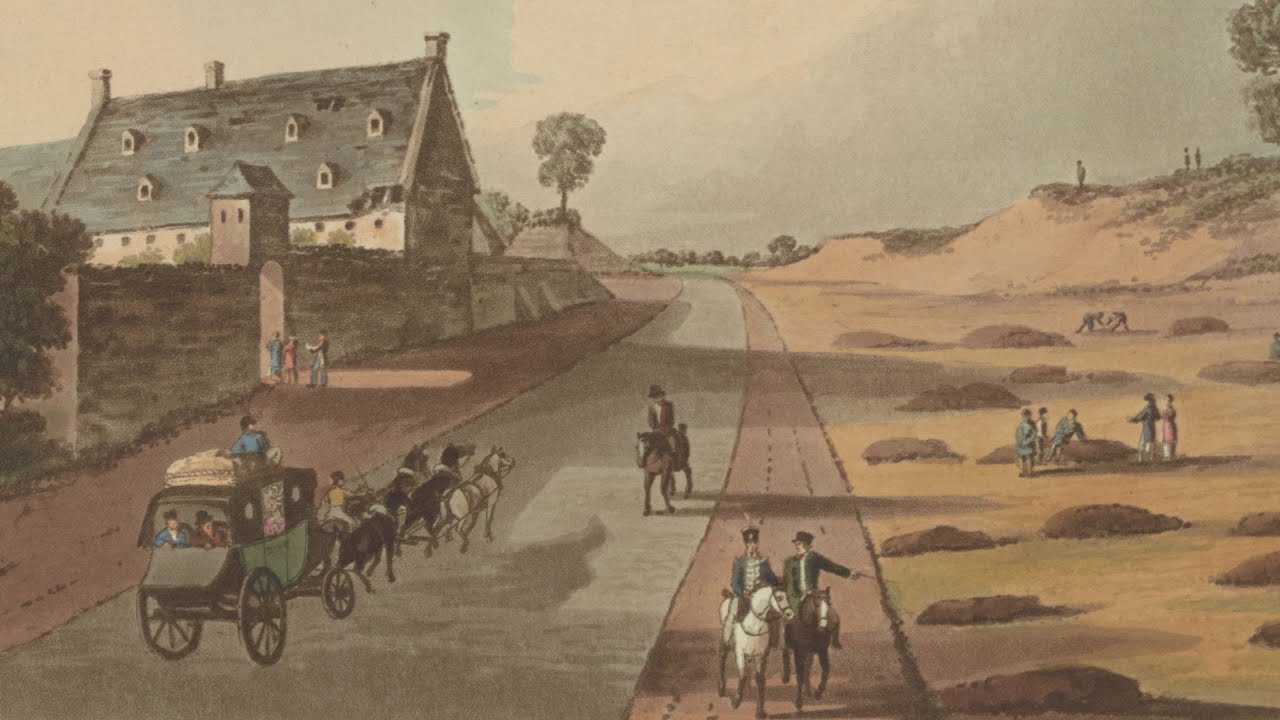
The above image clearly shows what must be the affects of some sort of major piece of engineering work on the Charleroi Road, you can see that the road has been widened and the embankment to its east has been cut well back leaving a wide open space which probably didn't exist at the time of the battle. I have no idea what the little mounds are, but they might be mass graves, although archaeologists have failed to find any evidence of burials on the battlefield.

This photograph clearly shows what looks like a railway line running past the farm, which would certainly account for the widening and reshaping of the road and landscape.

This print showing the clean up operation soon after the battle clearly shows the Charleroi Road running through quite a deep cutting, and the land in the foreground is clearly higher suggesting that the artist was actually standing on the rise overlooking the farm. Note: how the road appears to disappear near the bottom left of the print suggesting that it is running into a cutting/defile which is below the artists line of sight.
It also explains why French Cavalry support seemed to be so ineffectual and late in arriving to support D'Erlon's attack. Positioned as it was in the dead ground, which was mostly to the west of the Charleroi Road actually crossing the road to assist D'Erlons main attack columns would have been slow and tricky to do in a dense mounted formation. The Household Brigade had similar problems riding to the assistance of Halketts infantry caught in the wheat field west of La Haie Sainte, and their attack was fragmented and scattered by the time they managed to get across it. In fact, we now know that the only really effective cavalry support provided by the French was from just 200 Cuirassiers led by Colonel Crabbe who were not sheltering behind the rise but who have been sent forward to scout the valley west of the spur. Crabbe who was an ADC was on a special mission to establish whether the spur was occupied and whether it could be used as a forward observation post, as it was the only point on the entire battlefield from which everything was visible along the entire line, and so vital for coordinating both the French attacks and the Allied defence. It constantly changed hands throughout the day with both sides trying to secure it to provide them with a tactical advantage, even the Prussians managed to place an artillery battery on it late in the day, and earlier the Imperial Guard had tried to hold it by placing a square on it, that was shot to pieces and charged with the bayonet by the Nassau Regiment led by the Prince of Orange.
However, early in the battle Crabbe was sitting on it with his escort of 200 cuirassiers hidden in the dead ground below, and it was his initiative that led to the destruction of the Luneberg battalion which was sent forward to clear the skirmishers of the 13e Leger from the wheat field. The sudden charge of French cavalry, came not from the south but from the west, over the spur and into the flank of the Luneberg Battalion scattering them to the four winds together with over half the garrison of La Haie Sainte which had left the farm to help chase the French off, including Baring himself who was fortunate to be on his horse and managed to spur north and out pace his pursuers by leaping the sunken lane and taking shelter in one of the Allied Squares. It was this attack which prompted Uxbridge to order the Household Brigade to counter-attack, and led to the sequence of events including the charge of the Scots Greys and the intervention of the main French cavalry supports who were able to move forward more effectively on the west of the road, to counter the Household Cavalry and support the 13e Legere.

Whilst not by Siborne, this map does at least show the spur and shows clear indications of the steep banks that lined both sides of the Charleroi Road for most of its length.
One thing that I find interesting is to speculate whether Wellington was an absolute genius, and recognised the value of La Haie Sainte not just as a walled fortification, but also as a position protected from French artillery by the lie of the land, or whether he was just lucky. The protection for Hougoumont and Papelotte was obvious in that both were masked by tree's, but did Wellington spot the rise as significant?
As far as vegetation is concerned the field boundaries and crops growing in them were noted by Siborne, as was the existence and height of the hedgerows between them. I noted on another thread that for some reason SOWG seems to have much better textures for vegetation than SOWW, and i was thinking of trying to copy the graphics files over to see it I could improve the look of the Waterloo maps. The rye and wheat in SOWW is particularly unimpressive compared to SOWG.
++++
Last night I spent some time trying to find an online image of the print I recall seeing of the view from La Haie Sainte towards the French positions on the southern ridge. I distinctly remember this print because its the only one I've seen that shows both the sharp rise of ground immediately to the south of the farm that protected it from the French artillery, and the defile caused by the cutting created to lessen the slope of the road to Charleroi. However, I could find a copy online and I suspect the image i remember is hiding in one of my many books on the battle and short of thumbing through all of them I'm not going to find it.
These cuttings are a feature of many roads of the period, both in Europe and America and were both a natural result of the poor road surface and the passage of wheeled carts, and also of deliberate action by local farmers to reduce the degree of slope, or flatten the road surface so that heavily laden farm carts could navigate them easier and with less risk of overturning.
I've also come across at least three primary references to this rise and the defile in the Charleroi road. Baring himself mentions the rise as a nuisance and risk, he claimed that the orchard occupied by his riflemen was overlooked by this rise which the southern edge of the orchard partially mounted, such that French skirmishers were able to approach well within effective musket range of his men in the orchard and fire down into them making the orchard extremely dangerous, especially for people like himself who were mounted and thus clearly visible. He also mentions that when the French assault began it appeared almost without warning less than 50 yards from his men in the orchard forcing a rapid withdrawal through the barn into the farm.
Another account is from a French Artillery officer, whose name I can't recall off-hand. He left a journal which is very interesting as it provides one of the few detailed records of how French artillery were deployed and controlled both before and during a battle. He states that on the morning of the battle he rode forward onto the rise south of La Haie Sainte, with the intention of marking the positions of the Grand Battery which it was intended would occupy the rise in order to bombard the farm and the Allied Centre. His job was to place markers along the rise indicating the position to be taken up by each gun, and then as the guns came up to their marks to indicate the line of fire to be assumed by each gun and make sure that wheel marks were placed to regulate the direction of fire once the battle started. However, as he was going about this task he quickly became aware that there were riflemen in the orchard very close to him, and he had to abandon his task and find less suitable locations for his guns further back on the main ridge. As it happens the French artillery were not able to deploy on the rise until much later in the day, after the KGL rifles had been driven out of the orchard and the farm had been invested by the 13e Legere. In fact, it may have been the guns brought forward to occupy this rise which were overrun during the charge of the Union Brigade, who may actually have caught them in the process of deploying on it, as there are numerous accounts of the limber drivers being with the guns when they were overrun which would not normally be the case.
The final account which was somewhat of a puzzle for me for some time was the description of 30-50 Cuirassiers being trapped in a defile trying to fallback from an attack and massacred by British infantry fire. I spent some time trying to work out where this event occurred, and at first I was looking behind Hougoumont but could never find a defile that was so restrictive it would have trapped a whole troop of French cavalry. It wasn't until a few years ago that i realised I was probably looking in the wrong place and that the defile was most likely along the Charleroi road. It makes perfect sense of course that the French heavy cavalry that were providing support for D'Erlon's attack would have deployed behind the rise south of La Haie Sainte. It was the closest they could get to the infantry assault without attracting direct artillery fire from the Allied Ridge, because the slope would have deflected any shot fired at them just as the Allied Ridge protected Wellingtons cavalry. So, French cavalry returning from a sortie would naturally have been heading back down the Charleroi Road towards the dead ground where they were being mustered and reformed for the next attack.
The interesting thing here is the inconsistency of the images and maps one see's of the farm and the road. Contemporary prints of the period conflict. Some show the Charleroi Road heavily sunken into the terrain, particularly as it climbs the slope towards the Allied ridge and as it climbs the slope of the rise the the south of the farm. It also shows that the road and the farm were lower than the surrounding farm land to the east, so that for most of its journey between the Allied and French ridge it was at least in part a sunken lane.
However, other images show what looks like an amazing transformation, where the road now looks like a wide open tree lined Chassee, with a large flat open expanse to the east where the other images show a steep bank. My suspicion is that this shows the effects of the battlefield clear up operations carried out soon after the battle. Either that or it was part of some municipal road widening scheme that reflects the growing popularity of the road. It may even be tied into the major earth gathering that took place to build the Lion mound.
But whatever the cause there is a clear discrepancy both in the images and the maps of the area. My belief is that at the time of the battle the road was heavily defiled along most of its length, and that it was a troop of French cavalry trying to negotiate this route that found their retreat suddenly blocked by a barricade, which we know existed to prevent French cavalry using the road as a route into the Allied rear. Blocked from continuing along the road, and trapped by the high banks on both sides they then came under point blank fire from Allied infantry standing above them on the roads embankment and massacred.
The above image clearly shows what must be the affects of some sort of major piece of engineering work on the Charleroi Road, you can see that the road has been widened and the embankment to its east has been cut well back leaving a wide open space which probably didn't exist at the time of the battle. I have no idea what the little mounds are, but they might be mass graves, although archaeologists have failed to find any evidence of burials on the battlefield.
This photograph clearly shows what looks like a railway line running past the farm, which would certainly account for the widening and reshaping of the road and landscape.
This print showing the clean up operation soon after the battle clearly shows the Charleroi Road running through quite a deep cutting, and the land in the foreground is clearly higher suggesting that the artist was actually standing on the rise overlooking the farm. Note: how the road appears to disappear near the bottom left of the print suggesting that it is running into a cutting/defile which is below the artists line of sight.
It also explains why French Cavalry support seemed to be so ineffectual and late in arriving to support D'Erlon's attack. Positioned as it was in the dead ground, which was mostly to the west of the Charleroi Road actually crossing the road to assist D'Erlons main attack columns would have been slow and tricky to do in a dense mounted formation. The Household Brigade had similar problems riding to the assistance of Halketts infantry caught in the wheat field west of La Haie Sainte, and their attack was fragmented and scattered by the time they managed to get across it. In fact, we now know that the only really effective cavalry support provided by the French was from just 200 Cuirassiers led by Colonel Crabbe who were not sheltering behind the rise but who have been sent forward to scout the valley west of the spur. Crabbe who was an ADC was on a special mission to establish whether the spur was occupied and whether it could be used as a forward observation post, as it was the only point on the entire battlefield from which everything was visible along the entire line, and so vital for coordinating both the French attacks and the Allied defence. It constantly changed hands throughout the day with both sides trying to secure it to provide them with a tactical advantage, even the Prussians managed to place an artillery battery on it late in the day, and earlier the Imperial Guard had tried to hold it by placing a square on it, that was shot to pieces and charged with the bayonet by the Nassau Regiment led by the Prince of Orange.
However, early in the battle Crabbe was sitting on it with his escort of 200 cuirassiers hidden in the dead ground below, and it was his initiative that led to the destruction of the Luneberg battalion which was sent forward to clear the skirmishers of the 13e Leger from the wheat field. The sudden charge of French cavalry, came not from the south but from the west, over the spur and into the flank of the Luneberg Battalion scattering them to the four winds together with over half the garrison of La Haie Sainte which had left the farm to help chase the French off, including Baring himself who was fortunate to be on his horse and managed to spur north and out pace his pursuers by leaping the sunken lane and taking shelter in one of the Allied Squares. It was this attack which prompted Uxbridge to order the Household Brigade to counter-attack, and led to the sequence of events including the charge of the Scots Greys and the intervention of the main French cavalry supports who were able to move forward more effectively on the west of the road, to counter the Household Cavalry and support the 13e Legere.
Whilst not by Siborne, this map does at least show the spur and shows clear indications of the steep banks that lined both sides of the Charleroi Road for most of its length.
One thing that I find interesting is to speculate whether Wellington was an absolute genius, and recognised the value of La Haie Sainte not just as a walled fortification, but also as a position protected from French artillery by the lie of the land, or whether he was just lucky. The protection for Hougoumont and Papelotte was obvious in that both were masked by tree's, but did Wellington spot the rise as significant?
Didz- Posts : 155
Join date : 2017-07-03
Age : 69
Location : UK
» Gettysburg map, can be scaled to KS size
» Impromptu Games
» When I try to make a Sandbox game is SOWGB the game crashes.
» Lines of Wellington movie
» Waterloo 3D
» Impromptu Games
» When I try to make a Sandbox game is SOWGB the game crashes.
» Lines of Wellington movie
» Waterloo 3D
Page 1 of 1
Permissions in this forum:
You cannot reply to topics in this forum